Alpharetta's 11 main areas, from downtown to Windward: ZIP codes, zoned high schools and August 2026 Zillow home values for each, with a map.
Last checked Oct. 4, 2026. Sources: the City of Alpharetta’s Horizon 2045 Comprehensive Plan (PDF) and small-area plans, Fulton County Schools address map data, the state’s 2025 School Grades data, Zillow Research, the Census Bureau and OpenStreetMap.
Alpharetta is a city of 66,855 people in north Fulton County, according to the Census Bureau’s 2020-2024 American Community Survey five-year estimates. Georgia 400 runs through the middle of it from southwest to northeast. Downtown, with City Hall at 2 Park Plaza, sits west of the highway on Main Street, which is State Route 9. Office parks line both sides of Georgia 400, and most of the city’s subdivisions spread out east and west of them.
Three things to know before you look at a listing:
- City limits are irregular. A mailing address that says “Alpharetta” can be in Milton, Roswell or Johns Creek. Check the city on the parcel with the Fulton County Board of Assessors before you count on Alpharetta police, fire and trash service.
- Five ZIP codes, three of them shared. Fulton County Schools’ address data puts Alpharetta addresses in 30009, 30005, 30022, 30004 and 30076. Zillow files 30022 under Johns Creek, 30004 under Milton and 30076 under Roswell.
- School zones do not follow city limits. Alpharetta addresses are zoned to six Fulton County Schools high schools. Of those six, only Alpharetta High is inside city limits, the district’s school records show. Always check one address with the district’s Find Your School lookup.
The city’s comprehensive plan says single-family detached homes make up nearly 60% of Alpharetta’s housing, more than 15,000 units, with rentals concentrated along the Georgia 400 corridor.
The areas at a glance
High school shares are of the area’s addresses in the district’s map data on Oct. 4. Home values are the Zillow Home Value Index for August 2026: a modeled typical value for the middle third of homes in the whole ZIP code, not a sale price. The citywide figure was $716,629.
| Area | Main ZIP code | Zoned high school (most addresses) | Typical value, main ZIP |
|---|---|---|---|
| Downtown | 30009 | Alpharetta (41%), split with Cambridge and Milton | $759,646 |
| Mayfield Road and Cumming Street | 30004 and 30009 | Alpharetta (57%) | $757,088 (30004) |
| Highway 9 North | 30009 and 30004 | Cambridge (65%) | $759,646 (30009) |
| Crabapple side | 30004 | Milton (100%) | $757,088 |
| South Main | 30009 | Milton (96%) | $759,646 |
| Avalon and Old Milton Parkway | 30009 | Alpharetta (63%) | $759,646 |
| North Point | 30009, 30022, 30076 | Milton (53%) | $759,646 (30009) |
| Brookside and Kimball Bridge | 30022 and 30005 | Alpharetta (92%) | $668,627 (30022) |
| Haynes Bridge Road | 30022 | Johns Creek (47%) | $668,627 |
| Webb Bridge | 30005 | Alpharetta (91%) | $753,318 |
| Windward | 30005 | Alpharetta (95%) | $753,318 |
Map of the areas
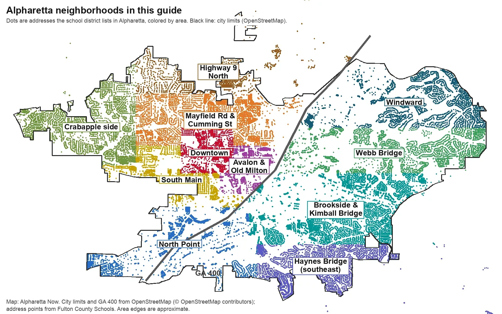
Map by Alpharetta Now. City limits and the line of Georgia 400 are from OpenStreetMap, © OpenStreetMap contributors; the dots are address points from Fulton County Schools’ map service. Area edges are approximate.
West of Georgia 400
Downtown. The city’s historic center, inside the boundary on the city’s official downtown map. The comprehensive plan says it has seen “unprecedented transformation” since the 2015 Downtown Master Plan, and calls for “measured and thoughtful” growth. High school zones split three ways here.
Mayfield Road and Cumming Street. The older neighborhoods north of downtown, with homes “built largely in the 1960s,” the plan says, and many renovations and knock-down rebuilds. Mostly Alpharetta High.
Highway 9 North. Alpharetta along Highway 9 and Cogburn Road north of Windward Parkway, inside the study area of the 2024 Windward Parkway and Highway 9 plan that the city wrote with Milton. Mostly zoned for Cambridge High.
Crabapple side. West Alpharetta along Mayfield, Rucker and Broadwell roads, up to the Crabapple crossroads in Milton. Every address in the district’s data is zoned for Milton High. Old Rucker Park and Farm is here.
South Main. Highway 9 from downtown to the Roswell line, studied in the city’s 2023 South Main Livable Centers Initiative plan, with Wills Park on its west side and Alpha Park among its older streets. Almost all Milton High.
Avalon and Old Milton Parkway. The district around Avalon, which lists 637 homes in its 86 acres, plus the Northwinds area and older subdivisions between downtown and Georgia 400. Every address is zoned for Manning Oaks Elementary.
Both sides of the highway
North Point. The roughly 670-acre district around North Point Mall between Mansell and Haynes Bridge roads. The comprehensive plan names it the city’s main growth opportunity. School zones split between Milton and Centennial high schools, and four of its schools are on the district’s rezoning list.
East of Georgia 400
Brookside and Kimball Bridge. Office parks and subdivisions along Brookside Parkway and Kimball Bridge Road, with Rock Mill Park, the greenway’s main access point. The plan expects hundreds of new homes in Brookside.
Haynes Bridge Road. The southeast corner of the city, all ZIP 30022, shared with Johns Creek. Its addresses are zoned to four different high schools, more than any other area here.
Webb Bridge. Webb Bridge Road east from Georgia 400, with Alpharetta High, Creek View Elementary, Webb Bridge Middle and Webb Bridge Park along it.
Windward. Windward Parkway east of Georgia 400: office campuses, Lake Windward and the north end of the Big Creek Greenway. Mostly Alpharetta High.
Comparing Alpharetta with its neighbors
Taxes, schools, home values and commutes for Alpharetta, Milton, Roswell and Johns Creek side by side: Alpharetta vs Milton vs Roswell vs Johns Creek. For the citywide market, see our home prices guide; for every school and its zone, our schools guide and public schools list. Getting set up: moving here.
How we built this
We named only areas a public source places on a map. The sources were:
- The city’s plans. The Horizon 2045 Comprehensive Plan, adopted June 22, 2026, and its five focus areas (North Point, Windward east of Georgia 400, Great Oaks/Royal 400, Brookside and Downtown); the official downtown boundary map; the North Point LCI; the South Main LCI report (PDF); and the Windward Parkway and Highway 9 plan (PDF).
- OpenStreetMap place names inside the city, such as Alpha Park, Preston Ridge, Haynes Forest and Thornberry, and Crabapple just outside it.
- ZIP codes and school zones from every Alpharetta address point in the Fulton County Schools map service.
The city’s neighborhoods page does not publish a neighborhood or HOA list, so these pages do not list homeowners associations. We left out Great Oaks, which the plan describes as offices, data centers and a church, not homes, and Ocee, which OpenStreetMap places in Johns Creek. Area edges between plan districts follow main roads and are approximate; the zone lookup and the county’s parcel records are the authority for any one address. Store and place data are © OpenStreetMap contributors.
Frequently asked questions
What are the neighborhoods in Alpharetta?
Our guide covers 11 areas: Downtown, Mayfield Road and Cumming Street, Highway 9 North, the Crabapple side, South Main, Avalon and Old Milton Parkway, North Point, Brookside and Kimball Bridge, Haynes Bridge Road, Webb Bridge and Windward. The names come from the city’s plans and OpenStreetMap.
What ZIP codes are in Alpharetta?
Alpharetta addresses use five ZIP codes: 30009, 30005, 30022, 30004 and 30076. Zillow files 30005 and 30009 under Alpharetta, 30022 under Johns Creek, 30004 under Milton and 30076 under Roswell, because those three ZIP codes are shared with neighboring cities.
Do Alpharetta school zones follow city limits?
No. Fulton County Schools zones Alpharetta addresses to six different high schools, including Cambridge and Milton high schools in Milton, Centennial High in Roswell, and Chattahoochee and Johns Creek high schools in Johns Creek.
Which side of GA 400 is downtown Alpharetta on?
The west side. Downtown, Avalon, South Main and the Crabapple side are west of Georgia 400; Windward, Webb Bridge, Brookside and the Haynes Bridge Road area are east. North Point straddles the highway.
Have your say